Skip to content
AdventureX4x4

Route dossier

Leh Ladakh road trip

A Leh Ladakh road trip package is a self-drive 4x4 expedition through the high Indian Himalaya — best run June to September, when the passes open and the Changthang lakes are reachable. This is the route dossier: Manali–Leh versus Srinagar–Leh, Khardung La and Pangong, the Nubra Valley, inner-line permits, acclimatisation at 3,500 m, and the fuel and water plan that keeps a Ladakh self-drive expedition moving. Our guided Ladakh Loop runs the full circuit — roughly 2,400 km over fourteen days.

A 4x4 on a high-altitude overland route through the mountains of Ladakh
2,400 km
Loop distance
5,359 m
Khardung La
14 days
Itinerary
§ 00Two roads to Leh

Manali–Leh vs Srinagar–Leh, side by side

Both roads reach Leh; the smart plan uses one in and the other out. Srinagar–Leh is the gentler acclimatising entry; Manali–Leh is the wilder, higher exit once your body has adjusted.

Comparison of the Manali–Leh and Srinagar–Leh driving routes into Leh, Ladakh.
FactorManali–LehSrinagar–Leh
Approx. distance to Leh≈ 475 km (2 days)≈ 420 km (2 days)
Highest pass en routeTaglang La — 5,328 mFotu La — 4,108 m
Acclimatisation profileAggressive — multiple 5,000 m+ passes earlyGentler — gains altitude in stages, kinder on the body
Typical season openLate May / June to mid-OctoberMay to November (longer window)
Road characterWilder, remote, fewer settlements, more dramaticGreener start, more towns, Kargil & Drass en route
Best used asThe exit — descend out after you're fully acclimatisedThe entry — easier altitude build on the way in
§ 01The route, decoded
A 4x4 overland route climbing through the high-altitude desert mountains of Ladakh

What a Leh Ladakh road trip actually involves

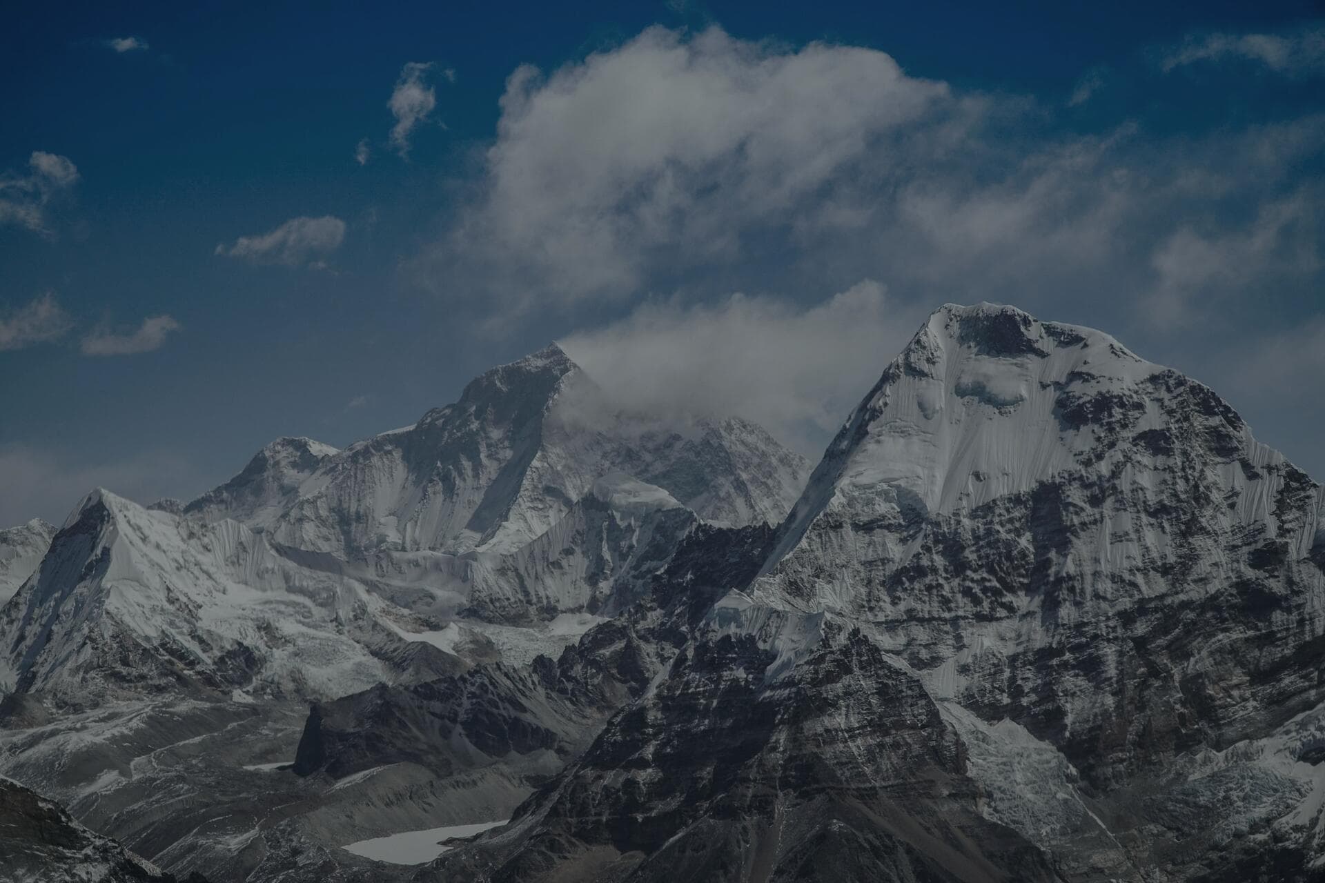
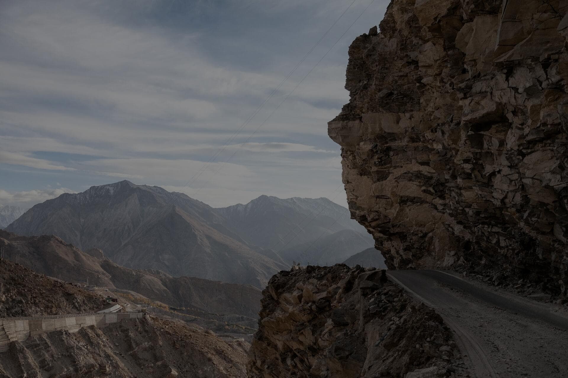
A Leh Ladakh road trip is a high-altitude overland loop, not a hill-station holiday with a few viewpoints. Leh, the regional hub, sits at about 3,500 m, and almost everything worth driving to from there is higher: Khardung La at 5,359 m on the way to Nubra, Chang La at 5,360 m on the way to Pangong, the Changthang plateau lakes at 4,300–4,600 m, and — for those who go all the way south — Umling La, the world's highest motorable road at 5,883 m. The classic circuit threads Leh, the Nubra Valley, Pangong Tso, the Hanle dark-sky reserve and Tso Moriri before closing the loop over Taglang La. Our Ladakh Loop expedition runs that full circuit across roughly 2,400 km in fourteen days, and the distance is deceptive — at this altitude, on broken pavement and washboard gravel, a 160 km day is a full day's driving.

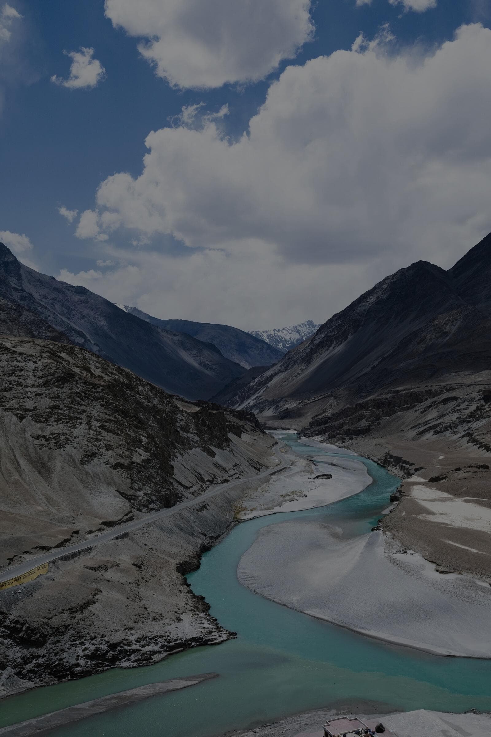
The window is short and non-negotiable. The high passes and the Changthang lake roads are practically only open from June to September; outside that, snow closes Khardung La and the southern lakes, and even the through-roads to Leh shut for the winter. Within the season the experience is extraordinary — a cold high-altitude desert of ochre and violet rock, monasteries clinging to ridgelines, double-humped camels on the Nubra dunes, and night skies at Hanle so dark they run a working observatory there. Everything below is how we run it so the rig keeps moving and the people in it stay well.

§ 02Two ways in
High Himalayan passes on the approach roads to Leh in Ladakh

Manali–Leh or Srinagar–Leh: which road, and why both

There are two driving routes into Leh, and the smart move on a longer trip is to use both — in one over the gentler road, out over the wilder one once you are fully acclimatised. The Srinagar–Leh highway (about 420 km) is the kinder approach: it gains altitude in stages through Sonamarg, Zoji La, Drass and Kargil, with its highest pass, Fotu La, at a relatively modest 4,108 m, and you sleep at lower elevations along the way. That staged climb is genuinely better for your body, which is why we favour it as the way in.

The Manali–Leh highway (about 475 km) is the spectacular one and the more demanding one. It throws you across the Rohtang/Atal Tunnel corridor, the Gata Loops, Baralacha La (4,890 m), Lachulung La (5,059 m) and Taglang La (5,328 m), with long, remote stretches between fuel and food and far fewer places to bail out if the weather turns. Driven cold on day one it is a recipe for altitude sickness; driven as the exit, after a week acclimatising on the Ladakh side, it is one of the great mountain drives on earth. The comparison table above lays the two side by side so you can plan the in-and-out properly.

§ 03Passes & lakes
A glacial river and high-altitude lake basin on the Changthang plateau of Ladakh

Khardung La, Nubra, Pangong and the Changthang lakes

The set-piece destinations are what people book a Ladakh 4x4 tour for, and each has its own demand. Khardung La (5,359 m) is the gateway north to the Nubra Valley — a sustained high-altitude climb where you do not linger at the top; you photograph the sign, keep moving, and descend to sleep low at Hunder (about 3,050 m) among the sand dunes and the Bactrian camels. Pangong Tso, the 134 km lake straddling the India–China line, is reached over Chang La (5,360 m) or via the dramatic Shyok river route from Nubra; the shoreline camps sit at roughly 4,350 m, which is high to sleep, so you earn it by acclimatising first.

South and east of Pangong the road empties out into Changthang — the high plateau of Hanle (the dark-sky reserve and observatory at ~4,500 m), Tso Moriri (~4,520 m) and Tso Kar, with Changpa nomad camps and the option, for the committed, of tagging Umling La at 5,883 m. This is the most remote driving of the trip: settlements are tiny and far apart, mobile coverage is gone, and self-sufficiency is the rule. It is also, for many of us, the best of Ladakh — the part that feels genuinely off the edge of the map.

§ 04Permits & acclimatisation
A rooftop-tent expedition camp on a high plateau under clear Ladakh skies

Permits, altitude and staying well at 4,500 m

Two pieces of admin gate the good stuff: permits and acclimatisation. Nubra, Pangong, Hanle, Tso Moriri and the wider Changthang circuit all sit in protected/inner-line zones, so you need a permit — historically the Inner Line Permit (ILP), now issued to Indian nationals as a protected-area permit and to foreign nationals as a separate PAP — arranged in Leh before you head out, with photocopies carried for every checkpoint. On a supported self-drive Ladakh expedition we arrange all of these for you; doing it solo means a half-day in Leh at the DC office or the online portal before you can legally cross to Pangong or Nubra.

Acclimatisation is not optional and it is not something willpower fixes. Leh itself is 3,500 m, and the cardinal rule is to spend your first two days there doing almost nothing — no passes, no Pangong dash on day one. After that, climb high but try to sleep lower where the itinerary allows, hydrate far beyond what feels natural in the dry cold, and watch everyone in the group for headache, nausea, breathlessness or poor sleep. Carry Diamox and a supply of supplemental oxygen, and understand that the only real cure for worsening altitude sickness is to descend. Our Ladakh Loop builds two rest nights into the start and runs with oxygen and a medic precisely because this is where unsupported trips get into trouble.

§ 05Fuel, water & the rig
Sand dunes and a desert valley floor in the Nubra region of Ladakh

Fuel range, water and how to set up the vehicle

Ladakh punishes poor logistics quietly. The last dependable fuel stations are in Leh, with smaller, less reliable supply at Diskit (Nubra) and Karu on the Pangong road — beyond those you are on what is in your tank, so plan for a real-world range of 350–400 km of thin-air, low-gear driving and carry a jerrycan for the Changthang legs. A diesel 4x4 with low range and good ground clearance is the right tool for the water crossings on the Shyok route and the washboard to Tso Moriri; petrol crossovers make it, but with far less margin. Tyres take a beating on the sharp gravel, so carry a full-size spare, a plug kit and a way to re-inflate after you air down for the rough sections.

Water is the logistics problem people forget. Between Leh and the lakes you can go a full day without a clean, reliable source, and bottled water at altitude is both expensive and a mountain of plastic. We run a pressurised tank on the rack — the kind of self-contained water system that turns a fragile day into a comfortable one — so the camp kitchen, washing and drinking water are sorted without hunting for a tap. Pair that with a rooftop sleep system rated for cold high-altitude nights, recovery gear you know how to use, and the right cross-link below, and a self-drive Ladakh expedition stops being a gamble and becomes a genuinely repeatable trip.

“Ladakh doesn't catch people out on the famous passes. It catches them on day two, before they've acclimatised, and on the empty stretch where the tank ran low and there was no water. Rest in Leh, carry your range, carry your water — then go drive the best roads in the country.”

Dinesh, founder — on every Ladakh briefing

Rather drive it supported?

Drive your own rig — we carry the permits, the mechanic and the oxygen

Our Ladakh Loop is the supported self-drive version of everything on this page: a fourteen-day, ~2,400 km circuit through Khardung La, Nubra, Pangong, Hanle and Tso Moriri, run in the long summer window with a lead vehicle, an expert guide, a mechanic, every inner-line permit, oxygen and a medic — and two acclimatisation nights built into the start. You keep the wheel; we remove the exposure.

Guided · intermediate grade

14 days · Jun – Sep

Every pass, every lake — the classic Ladakh circuit, supported.

§ 06Frequently asked

Ladakh by road, answered

The questions we field before every Ladakh departure — season, the two roads, permits, Khardung La and how to stay well at altitude.

June to September is the reliable window. By June the Manali–Leh and Srinagar–Leh highways and the high passes — Khardung La, Chang La, Taglang La — are open, and the Changthang lake roads to Pangong, Hanle and Tso Moriri are reachable. July and August are the warmest and busiest; September is quieter with crisp, clear skies but colder nights. Outside this window snow closes the passes and the southern lake circuit, so a winter Ladakh self-drive is not feasible for the full loop.

On a longer trip, do both: enter via Srinagar–Leh and exit via Manali–Leh. The Srinagar route (≈420 km) gains altitude more gently — its highest pass, Fotu La, is only 4,108 m — so it acclimatises you better on the way in. The Manali route (≈475 km) crosses Baralacha La, Lachulung La and Taglang La above 4,800–5,300 m and is far more demanding; it is best driven as the exit, after a week acclimatising in Ladakh, when your body can handle the high passes. Driving Manali–Leh cold on day one is a common cause of serious altitude sickness.

Yes. Nubra, Pangong, Hanle, Tso Moriri and the Changthang circuit are protected/inner-line areas. Indian nationals need a protected-area permit (the system that replaced the old Inner Line Permit), and foreign nationals need a Protected Area Permit — both arranged in Leh, online or at the DC office, before you set out, with photocopies carried for the checkpoints. On our supported Ladakh Loop expedition we arrange every permit for you; on a solo run, budget a half-day in Leh to sort them before you can legally cross to Pangong or Nubra.

Khardung La is about 5,359 m — one of the world's highest motorable passes and the gateway to Nubra. The discipline at altitude is the same everywhere on this trip: rest two full days in Leh (3,500 m) before crossing any pass, do not linger at the top of Khardung La (photograph the sign and descend to sleep low at Hunder, ~3,050 m), hydrate aggressively, and carry Diamox and supplemental oxygen. Watch for headache, nausea and breathlessness, and remember the only real fix for worsening altitude sickness is to lose height and descend.

It is the middle path between a solo self-drive and a fully chauffeured tour: you drive your own 4x4, but a lead vehicle, an expert guide, a mechanic, all inner-line permits, oxygen and a medic travel with the convoy. You keep the experience of driving Khardung La and the Shyok route yourself while the things that turn a Ladakh trip dangerous — a breakdown 200 km from help, a missing permit, a bad altitude night — are handled. Our Ladakh Loop runs exactly this way over 14 days and roughly 2,400 km, which is why it is our most popular expedition.

Treat Leh, Diskit and Karu as your last reliable fuel; beyond them, on the Pangong and Changthang legs, you run on what is in your tank, so plan for a 350–400 km high-altitude range and carry a jerrycan for the lake circuit. Water is the bigger oversight — you can drive a full day between clean sources, and bottled water at altitude is costly and wasteful. We run a pressurised aluminium tank on the rack so drinking, cooking and washing water is self-contained for the dry legs. Add a cold-rated rooftop sleep system, a full-size spare, a plug kit and a way to re-inflate, and the remote sections become manageable rather than risky.

All expeditions
WhatsApp us